Avalanche Report for Northern Cairngorms
Issued
Avalanche Hazard Forecast
FOR PERIOD 18:00 Thu 16/04/2026 TO 18:00 Fri 17/04/2026

Forecast Snow Stability & Avalanche Hazard
Reports for North Cairngorm have now finished for the winter
Forecast Weather Influences

Observed Avalanche Hazard -
Observed Weather Influences
Observed Snow Stability and Avalanche Hazard
Reports for North Cairngorm have now finished for the winter
Mountain Conditions
Recent Avalanche Activity
Avalanches recorded in this forecast region within 7 days of this report.
1 Avalanche
View details | View on map
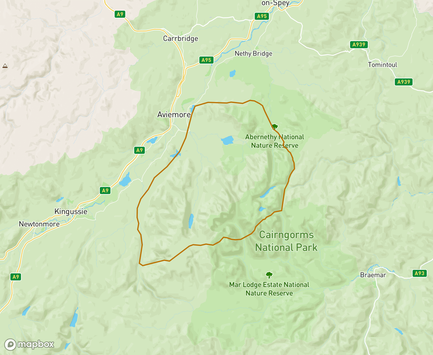
The Northern Cairngorms avalanche forecast Area
When producing daily avalanche forecasts for the Northern Cairngorms region the whole area and summits as indicated on the map are considered by SAIS forecasters when writing their daily reports.
In the Northern Cairngorms region the “core” forecast area primarily visited are the mountains and corries that surround the Cairngorm plateau. Knowledge from this core area is applied to the more outlying mountains such as Braeriach and the Sgorans, where field observations are carried out in turn as the winter progresses, or specific snowpack assessments are required.
-
Storm Dave
Improving stability, then storm Dave arrived and created a dynamic snowpack with fluctuating temperatures, strong winds and heavy snowfall. A warm sector of air dominated the weather for the later half of the period, allowing a slow consolidation of recent unstable windslab. A cold front is currently crossing the area bringing a lowering freezing level and blustery showers.
A mild spell in the middleAt the start of the period, there were cold temperatures with unstable windslab building on lee slopes. A mild spell followed with a thaw at all altitudes before the return of cold conditions, this helped to consolidate recent windslab accumulations. Cold temperatures returned with further snowfall, localised unstable windslab developed on lee slopes. Heavy snowfall expected over the next 24 hours with widespread unstable windslab developing on mostly NW to NE aspects.
New snowfallAt the start of the period there were stable conditions, the snowpack was very firm and well bonded throughout. Milder temperatures arrived and the snowpack began to slowly thaw at all altitudes. Later much cooler unsettled conditions arrived with snowfall. Currently localised unstable windslab is present on North through East to South aspects above 800 metres. This is expected to stabilise over the next 24 hours. Elsewhere the old snowpack is firm and stable.
Stable snowpackThe start of the period was cold with snowfall and drifting on Westerly winds. Unstable windslab accumulated on lee slopes of mostly North through East to South-East aspects. Milder temperatures followed and there was a short period of wet snow instability on some North to East aspects, soon after it became cooler and the snowpack consolidated. Currently the snowpack is firm well bonded and stable throughout. Glide cracks continue to develop in steep locations such as "The Great Slab".
Fluctuating temperaturesStart of period, a few centimetres of soft unconsolidated snow on all aspects. The following day significant drifting, unstable windslab developed on Northerly aspects. This overlay a softer weak layer. Milder conditions followed, the snowpack began to stabilise, lingering instabilities remained within deeper windslab accumulations on steep slopes. End of period, rain then heavy snow, above 1000m, currently roller ball activity steep N to E aspects, turning cooler with further snow.
Glide cracksAt the start of the period a thin cover of unconsolidated snow overlay a very firm snowpack. The following day there was gale force winds with further snowfall; new localised unstable windslab developed on steep lee slopes, elsewhere the old snowpack remained very firm and icy. Later in the period thaw conditions returned and glide cracks developed on some steep terrain but on the whole, the snowpack is firm well bonded and stable.
Thaw conditionsAt the start of the period there was a cold SE airflow with gale force winds. Deep accumulations of windslab were present on lee slopes above 500m with instabilities on steep slopes. Soon after milder temperatures with a general thaw at all altitudes. In the main the snowpack stabilised; however later in the period it became even milder with rain at all levels. This had an impact on the snowpack leading to wet snow instabilities, avalanches and cornice collapse on steep NW to N aspects.
ChangeableSettled conditions to start the period with windslab persisting on West to North aspects. An Atlantic low at the weekend brought heavy snow and followed by a rise in temperature and several avalanches were recorded on Sunday, Monday and Tuesday with windslab on many aspects. Storm force South-Easterly winds on Wednesday redistributed much of the soft snow and another avalanche was recorded on a North-West aspect. There was an improvement in stability to end the period.
Soft weak layer beneath firm windslabAt the start of the period it was cold with settled spells and fresh to strong winds. During this period on various aspects and altitudes there was some avalanche activity. Afterwards a thin cover of new snow lay on all aspects. Later it became unsettled with periods of snowfall combined with a redistribution of lying snow on storm force Southerly winds. Currently on mostly NW to NE aspects dense windslab overlies a soft weak layer beneath.
Widespread friable crustThe start of the period was a cold SE airflow with snowfall, poorly bonded windslab became more widespread. Early in the week, milder, the freezing level rose to around 1000m, rain below, sleet and snow above. After a period of instability cooler temperatures arrived, the old snowpack began to stabilise and a widespread friable crust developed at around 1000m. Currently weaknesses remain present beneath this, and in some area's this is overlaid with new unstable windslab.
South-Easterly airflowOver the past week there's been a constant SE airflow, with snowfall often on gale force winds. Windslab developed in lee areas, this was poorly bonded at higher levels. Later the freezing level rose towards 1000m before falling again, the snowpack began to consolidate, soon after poorly bonded windslab developed at higher levels, fluctuating temperatures consolidated this at lower levels, currently cooler conditions with further windslab developing, this is poorly bonded at higher levels.
South-Easterly airflowDuring the course of the week there has been spells of snowfall, sometimes heavy with significant drifting. Poorly bonded windslab continues to develop mainly above 900 metres on West through North to North-East aspects. Below 900 metres localised moderately bonded windslab has developed on steep banks and burn lines. Recently avalanche activity was noted on several steep NW to NE facing slopes.
Unsettled conditionsThe start of the period was cold with localised instabilities in lee areas. Unsettled conditions followed with snowfall leading to avalanche activity on Northerly aspects. A thaw freeze spell refroze the snowpack surface. localised windslab developed in lee areas. Again milder temperatures arrived with snowfall creating windslab above 1000m. The end of the period windslab is becoming more widespread and to lower levels with the onset of snow above 600 metres.
A period of instability.The period started with unconsolidated snow on all aspects generally above 500m, very cold temperatures, poorly bonded snow on lee slopes. Stormy conditions Sunday, Monday with S winds, and avalanche activity noted at 490m on a NE aspect. Later there was avalanche activity mainly on NW to N aspects at higher levels, these potentially released during the mild period on Sunday evening. Cooler temperatures followed, the snowpack stabilised. Currently Localised instabilities present in lee areas.
Unconsolidated snowDuring the course of the week there's been cold conditions with snowfall at all levels. Over time windslab accumulations became deeper and more widespread. In some areas weaknesses persist where this overlies buried surface hoar and facets. Mid period a thin crust developed. This is now buried and sits within the snowpack. The most recent accumulations of windslab are very poorly bonded, and in steep locations trigger easily. Better stability on South facing slopes less so on shaded aspects.
Windslab developingOver the course of the week the patchy snowpack was firm and stable throughout. Due to settled conditions surface hoar developed, this was followed by the arrival of a thin cover of new snow on all aspects. Currently conditions have changed with snow showers on a cold NW airflow. Unstable windslab is developing in lee areas. In some areas this overlies the surface hoar presenting a more unstable snowpack. Currently instabilities are localised but these are expected to become more widespread.
Firm stable snowDuring the earlier part of the week, there was snowfall with accumulations of windslab developing in lee areas above 950 metres. This stabilised fairly quickly due to fluctuating freezing levels. Thereafter the snowpack began to thaw, before the arrival of cool settled conditions. Currently the remaining snowpack is firm well bonded and stable throughout.
Firm old snowpackOver the course of the week there's been some very unsettled conditions with mostly mild temperatures, with some cooler spells. The stable snowpack has steadily depleted and is mostly confined to areas above 1000 metres. Currently the old snowpack is firm well bonded and stable. New unstable windslab is beginning to overlie these areas, and is expected to become more widespread over the next 24 hours.
A general thawCooler conditions at the start of the period, with isolated windslab accumulations developing mainly around coire rims. Later mild, wet and windy conditions set in leading to a general thaw at all altitudes. Currently the snowpack continues to thaw and is generally well bonded and stable throughout. The greatest extent of snow is above 1000 metres, around coire back walls, flanks and the plateau.
A slow thaw cycle underwayA return to wintry conditions early on with some heavy snowfall. After a short period of instability the snowpack has been slowly consolidating as the freezing level rose to around 1000 metres where it remains. Currently a soft but stable snowpack remains with most snow found above 900 metres.
Reset to StartFluctuating temperatures and snowfall helped stabilise the snowpack of recent days. A rapid thaw today (Thursday 27h) has drastically reduced the snow cover. Thankfully colder temperatures and snow are due to return in next days.
Surpising early SnowcoverA Northerly airstream has brought significant snow amounts to the Northern Cairngorms with other areas receiving less. Unstable Windslab is present in wind sheltered places primarily above 900m on E through S to SW aspects. Changing wind directions and drifting snow forming windslab on N to E aspects also. Shallow snow elsewhere. Milder temps and then cooler conditions will help consolidation and stabilise the snowpack in most areas by Sunday 23.11.
High pressureThe period started with a brief return to winter and snow was drifting above 950 metres. High pressure then set in and the freezing level rose above the summits. Any fresh snow quickly started to thaw. Currently only snow patches remain which are continuing to reduce in the mild temperatures. There is currently insufficient snow for an avalanche hazard.
Thaw conditionsThis past week has been dominated by mild conditions resulting in a depletion on the overall snow cover. A very brief spell of some colder weather mid week brought a superficial covering of fresh snow but this did not last long. The remaining snow patches are stable and well bonded. These can mostly be found on North-West to North-East aspects and sporadically dotted around the main Cairngorm plateau above 1000 metres.
High pressure, sun and snowHigh pressure was dominant through this period, giving settled weather across the area. Snow cover from around 600 metres with wind drifted accumulations developing initially on South-East through South to South-East aspects above 1000 metres. Some minor avalanche activity observed. Sunny days and clear nights stabilised the snowpack becoming firm and icy on most aspects. Sun exposed Southerly slopes softened in the strong spring sunshine as the freezing level rose at the end of period.
Return of winterAn unseasonably mild period resulted in rapid thawing and snow loss with just sparse snow patches remaining. A period of settled almost spring like conditions followed. Winter returned rapidly with the passage of an active front bringing rain followed by snow to the Northern Cairngorms. This northerly flow has continued with snow showers resulting in isolated windslab development above 1000 metres combined with blanket snow cover above 600 metres.
Cold followed by a thawCold dry conditions at the start of the period. Initially the snowpack was very firm with shallow, isolated accumulations of soft stable snow on North to East aspects above 1000 metres. During the start of the week it became mild and windy with periods of rain. Currently the snowpack remains stable and continues to thaw at all altitudes, is limited in extent and mostly confined to areas above 1000 metres such as coire back walls, ridge flanks and the plateau.
Thaw then colderThawing at start of the period, with rain at all levels led to a period of instability. Avalanche in the Northern Coires was reported. Colder conditions resumed after the weekend with the existing patchier snow cover becoming firm, icy and well bonded on most aspects. Snow showers and strong winds deposited isolated, shallow and avoidable snow accumulations on North to East aspects above 1000 metres.
Weak snowpackVery cold conditions for most of the period, with snow showers, and significant drifting on SSE to SSW winds. Windslab accumulations continued to build and due to the prolonged cold temperatures weaknesses developed within the snowpack. Although mainly in specific steep locations, there was human triggered avalanche activity and cornice collapse on NW to N aspects from Sunday onwards. Currently conditions are mild and wet with natural avalanche activity on Northerly aspects.
Windslab persisting, firm snowpack elsewhereSnow showers earlier in the week resulted in snow transport and new windslab accumulations. The greatest amounts of snow fell in the Southern Cairngorms, a significant volume of which was readily transported in cold temperatures on South-Easterly winds. A period of rapid windslab development occurred in wind sheltered areas, mostly on Northerly aspects. This windslab now presents as moderately bonded accumulations, with weaknesses persisting in the cold temperatures.
Firm snowpack shallow windslabAt the start of the period there was a good covering of snow on most aspects. Various aspects above 800 metres were affected by snowpack instabilities. By the weekend a period of mild temperatures arrived leading to a steady thaw. Moist stable snow remained above 800m. Cooler temperatures with light snowfall arrived on Tuesday evening. Currently the old snowpack is firm and stable with shallow accumulations of fragile windslab on steep N to E aspects mainly above 1000 metres.
Winter ReturnsThe arrival of Storm Eowyn on 24th Jan changed the Cairngorms from summer to winter again. Winter conditions have built throughout the week with further snow fall and freezing levels generally remaining around 600m. With the exception of a short lived 'rain event' to summit level on Tue 28th which developed a crust which still remains either on the surface or within the snowpack.
No hazard to reportFor the vast majority of this week there has been no avalanche hazard to report. Any remaining snow patches are firm and well bonded and mainly found on North through East to South aspects above 1000 metres. This changed on Thursday afternoon with the precursor to Storm Ewoyn when fresh light snowfall arrived over the highest tops.
A patchy landscapeDespite the good covering of snow from glen levels up, a significant thaw became established during the latter part of the weekend. Within a 24 hour period, the landscape dramatically changed to leave only snow patches and ribbons. Mild air has continued since, diminishing any remaining snow. Any remaining patches are moist with good stability.
Cold weak snowpackAt the start of the period, cold temperatures arrived with snowfall on gale to storm force winds. Localised unstable windslab developed, this stabilized during a calm spell and a widespread layer of surface hoar developed. Later this became buried on all aspects as snowfall arrived on strong Northerly winds. Poorly bonded accumulations of soft windslab became deeper and more widespread on lee slopes. Elsewhere there's a widespread blanket of stable, soft, unconsolidated snow from glen level up.
Winter returns with the New YearAfter a period of virtually no snow winter returned with generally thin snow cover in the area. Deeper unconsolidated areas of snow and unstable windslab have formed in isolated locations in wind sheltered places.
Initially cold, then thawingThe first half of the period was dominated by gale to storm force Westerly winds, with snowfall down to 600 metres. This led to instabilities primarily on North through East to Southerly aspects above 900 metres. These instabilities quickly consolidated with the onset of milder temperatures at the beginning of the week. Significant snow loss followed, with thawing at all levels. Remaining snow is primarily above 1000 metres on North-East to South aspects.
Fluctuating TemperaturesFollowing a period of temperature inversions, colder, dry conditions resulted in a firm and stable snowpack. Mild temperatures then resulted in thaw conditions and considerable snow loss on all aspects and elevations. The greatest snow cover was quickly confined to coire back walls, with isolated patches or ribbons extending to lower elevations. Bands of showers have resulted in a light dusting of snow and isolated windslab development as temperatures fluctuate.
InversionAt the start of the period Storm Darragh crossed the Highlands with significant amounts of snow, cold temperatures and Northerly winds. This led to a good covering of snow with deep drifts in wind sheltered locations. During the storm cycle the snowpack was unstable especially on SE to SW aspects above 900m with some avalanche activity noted on steep terrain. High pressure over the past few days has consolidated the snowpack which is generally stable throughout.
Cold with winter showersA sudden start to winter with a gradually developing snowpack. More widespread and deep in places above 1000m on East to Southerly aspects. New windslab in localised places overlies soft weak layer.
Freeze thaw cyclesAt the start of the period there was heavy drifting and cold temperatures, this was followed by mild wet conditions with avalanche activity on W to N aspects. Later fluctuating temperatures consolidated the snowpack. During Tuesday there was snowfall, deep unstable windslab developed on Southerly aspects. Mild temperatures arrived the following day with snow followed by rain, this led to wet snow instabilities on many aspects. Currently the snowpack is mostly stable and continues to consolidate.
Soft windslabOver the past few days there has been a cold North to Easterly airflow with snow showers. Soft accumulations of windslab have been constantly developing since the early part of the week. Although these accumulations are consolidating fairly quickly, instabilities have been ongoing due to continual drifting of new snow.
Soft snow beneath firm windslabEarlier in the period there was a blanket of soft snow on all aspects. Strong winds from the East followed and firm windslab developed on SW through NW to NE aspects. This overlay the soft snow creating snowpack weaknesses. During this time there was avalanche activity on a NW aspect at 1050m. Currently the snowpack is undergoing a consolidating trend; however instabilities remain within the snowpack especially within deeper accumulations.
Avalanche activityOn the 16th there were cold temperatures with snowfall which resulted in a blanket of soft snow on all aspects. The following day strong winds redistributed the snow onto NW to NE aspects; here denser windslab developed, and overlaid a soft layer beneath. As the windslab became deeper it became increasingly unstable with avalanche activity on these aspects. Later the snowpack gradually consolidated over the course of a few days. Currently the snowpack is well bonded and stable throughout.
Currently a stable snowpackOver the past week there have been cold temperatures with spells of snowfall and drifting on an Easterly airflow. Instabilities remained within the snowpack up until the first part of this week. Currently there are milder temperatures and the spring snowpack is well bonded and stable throughout. Cooler temperatures are expected over the next 24 hours, therefore the old snowpack will become much firmer.
Improving stabilityAfter a settled spell fresh snowfall arrived with significant drifting taking place during the 3rd and 4th March. The snowpack started to consolidate from the 5th with greatest instability found on North-West, North and North-East aspects above 900 metres. Lingering instabilities are still persisting but generally, snowpack stability is improving.
ColderThe freezing level has generally hovered around the 700 metre mark bringing some fresh snow. This has improved the snow cover to some degree but it remains limited. Winds have generally been from the South-West resulting in some build up of windslab on various aspects. A one day thaw on the 28th has improved snowpack stability but persistent weaknesses can still be found at some locations. Cold conditions continue.
Limited snow coverGenerally the snow cover has been diminishing over the week in the very mild temperatures. What snow has remained is generally stable and well bonded. The freezing level lowered to around 500 metres on 21st accompanied by small amounts of fresh snow on generally South-Westerly winds, resulting in isolated areas of unstable windslab.
Mild temperatures.Earlier in the week there were strong East then West winds with snowfall. Accumulations of windslab developed on various aspects. This overlaid a layer of surface hoar, which led to a persistent weakness at depth. Currently there are mild temperatures and the snowpack is thawing and consolidating at all altitudes.
Severe Thaw then Return to WinterEarly in the week the freezing level was well above the summits. This, combined with heavy rain, led to a wet snowpack and significant snow loss. The freezing level then dropped and the remaining snow became firm, icy and stable throughout.
Fluctuating temperaturesDuring the past week there have been periods of gale to storm force winds with spells of cold and mild air. The snowpack has been through several thaw freeze cycles and it continues to consolidate. Currently the stable snowpack is most widespread above 800 metres around coire back walls, shallow gullies and high plateau areas.
Stabilising snowpackAfter a period of instability with weak layers at depth, the snowpack has gradually become more stable as the moisture penetrated the snowpack and impacted any weak layers. The old snowpack has now largely consolidated and refreezes have made it firm and stable. New snow accumulations will now present unstable accumulations for a time.
Poorly bonded windslab.The very cold temperatures over the past week are maintaining snowpack weaknesses. Of recent days the snowpack has become much weaker and poorly bonded windslab has become deeper and more widespread. These accumulations continue to overlie persistent weak layers at depth.
Fragile crustEarlier in the week a thin soft covering of snow lay on all aspects. The following day some drifting took place which led to poorly bonded, shallow accumulations of windslab developing, these are generally avoidable and remain on NW to NE aspects above 900m. Cold conditions maintained these isolated instabilities. Currently a widespread, thin, friable crust has developed at higher altitudes. Although a surface crust, it's fragile and poorly bonded to the snowpack beneath.
A widspread friable crust.Over the past week accumulations of unstable windslab developed on various aspects, this was accompanied by fluctuating temperatures creating friable crusts within the snowpack. Most recently a new widespread friable surface crust developed. This overlies soft windslab beneath creating snowpack instabilties.
Stormy conditionsDuring the past week there has been a gradual increase in snow distribution. A few days ago snowpack weaknesses developed in some areas due to cooler temperatures. Most recently storm Gerrit crossed the mountains with snowfall above 500m on severe SE gales. Over the past 24 hours there has been fluctuating temperatures, this is helping the storm snow to consolidate. Currently unstable windslab is developing, with greatest instability at higher altitudes.
Limited firm snowpackInitially there was a shallow covering of snow, above 600 metres with firm patches of old snow beneath. Unsettled windy conditions arrived with significant snow loss. Most recently there have been further stormy conditions with fluctuating temperatures. Currently patches of firm stable snow remain above 1000 metres around coire back walls, shallow gullies and the plateau.
Localised instabilities continue to consolidateThe past few days have been cold with snow showers, this led to a thin blanket of soft snow which overlaid the old firm snowpack. Recently strong winds redistributed this creating localised deposits of windslab. Areas most affected were within steep wind sheltered terrain. Mild conditions are now gradually improving snowpack stability.
After a period of instability snow stability is improving.After a period of very cold and clear days which presented an unconsolidated snow base. Wind transportation gradually increased the hazard due to the development of windslab which overlay this weak base layer. A number of triggered and natural avalanches subsequently occurred. Mild conditions are now gradually improving snowpack stability.
Cold and Wintry start - Shallow unconsolidated snow coverGood soft snow cover on all aspects above glen levels, becoming deeper above 900m especially on East through South to Westerly aspects in wind sheltered hollows and basins. generally unconsolidated and stable.
Stable snowpack then unstable windslabDuring most of the period the snowpack was stable, with the freezing level fluctuating around the higher summits and some light snow showers. Over Tuesday night and during Wednesday this changed dramatically, with storm force winds and heavy snowfall leading to significant snow transportation and accumulations of unstable windslab in wind sheltered areas, mainly on NW through N to E aspects. On Wednesday night and during Thursday further windslab was deposited on Western aspects.
Isothermal snowpackA mostly dry week with occasional light snowfall and fluctuating temperatures. Currently the snowpack is thawing and generally well bonded and stable throughout, most widespread around coire backwalls and the plateau above 1000 metres. Ribbons of snow remain below.
A thawing snowpackDuring the start of the period a friable crust developed on all aspects. Shortly after this it was overlaid by a few centimetres of new snow. Unsettled conditions with drifting snow followed. New windslab developed creating a weaker snowpack, this was enhanced by the buried friable crust. Later a mild spell set in with rain at all levels. The snowpack became increasingly unstable leading to avalanche activity in steep convex locations. Currently the snowpack is thawing and consolidating.
Turning coolerOver the past week there were spells of unsettled conditions with some recent snowfall. In the main the snowpack has been generally stable. Recently new accumulations of unstable windslab developed at higher altitudes. These accumulations are beginning to consolidate. Turning cooler over the next few days with new accumulations of unstable windslab expected to develop.
Slowly StabilisingAfter a period of very cold temperatures, mild conditions and rainfall is slowly stabilising the snowpack. Widespread persistent weak layers are still present at depth, although these are expected to gradually diminish. Gradual snow loss continues below 900 metres, with cover becoming patchy in nature.
Widspread underlying weaknessVery cold temperatures, with soft unconsolidated snow at all levels. Beneath the blanket of soft unconsolidated snow, is an underlying snowpack weakness at depth on all aspects, this is especially poor on steep and convex terrain, where it's overlain by firm windslab. Very cold temperatures are set to continue with further snowfall, this will maintain weaknesses within the snowpack.
Snowfall ExpectedThere has been little change due to a stable high pressure system. The older snowpack is mostly confined to areas of very hard and icy snow on Northerly through East to South-East aspects above 1000m. Recent dustings of new snow have created a picture more reminiscent of winter, with some isolated and patchy soft windslab developing. Snowfall is expected over the weekend of the 4/5 March, which will result in a rapidly evolving avalanche hazard. Buckle up, winter is not over yet!
Fresh SnowA diminished snowpack mostly confined to areas of very hard and icy snow on Northerly through East to South-East aspects above 1000m. Recent new snow cover has presented a wintry scene. Cooler temperatures ahead may herald a winter reboot!
Well bonded snowpackAt the start of the period, localised windslab accumulations consolidated. Thereafter the fluctuating temperatures continued to consolidate the old snowpack which remains generally firm, well bonded and stable throughout. The snowpack is most widespread on Northerly through East to South-East aspects above 950 metres.
Slow ThawThe last week has mainly been associated with relatively mild summit temperatures, strong winds and a slow thaw. Strong winds and snowfall resulted in some windslab development at higher elevations, although any weaknesses are now slowly diminishing. Greatest snow cover in in northerly facing coires and plateau areas, with snow patches and ribbons in stream beds at lower elevations.
Thawing ConditionsThe period started with a firm, well bonded snowpack. Unstable accumulations of windslab gradually developed later in the period becoming more widespread until a significant thaw arrived. The current snowpack is thawing with some wet snow instabilities present.
Gradual consolidationThe period started with widespread windslab overlying a soft weak layer. There was a period of thaw and gradual consolidation through the week. The snowpack which is now much depleted, compared to the start of the week, has now refrozen, and is generally stable. Patchy cover remains below 850 metres, better cover above.
Unstable widespread windslabOver the last week new snow accumulations have slowly increased, especially from Friday the 13th when a soft widespread blanket of snow lay above 600m on all aspects. Subsequent snowfall and strong winds have created unstable windslab which overlies this soft weak layer. This has become deeper and more widespread over time and currently presents a significant hazard on many aspects.
Rapidly Changing Snowpack StabilityOver the last period weather systems have brought snowfall and fluctuating temperatures which has presented sequences of stable and unstable snowpack scenarios. Mostly unstable windslab development has been at higher elevations which have improved with warmer spells, but rapidly flipping to cold and unstable once again. Currently the snowpack is mostly stable but with localised instability in wind sheltered places above 1000m where it gains depth.
Natural Avalanches - Melt Freeze CyclesThe friable crusts from the previous week were still present within the snowpack over the weekend. Heavy snowfall and further wind transportation resulted in a natural avalanche in the early hours of Friday 30th, with other natural avalanches recorded during subsequent days, with failures occurring on the crust layers. Fluctuating freezing levels, rainfall and subsequent refreezes has consolidated the snowpack, which by the end of the period has become firm and generally stable.
Fluctuating temperaturesOver the past week there has been snowfall with fluctuating temperatures. Windslab has developed mostly above 900 metres. Within these accumulations, friable crusts have developed between softer unconsolidated layers; here snowpack weaknesses are evident. Elsewhere a firm patchy snowpack remains, this is most widespread above 800 metres. During Friday 30th, a period of heavy snowfall is expected on Southerly winds; during this time unstable windslab is expected to become more widespread.
Storm, thaw refreeze.Last weekend stormy conditions led to the development of widespread accumulations of windslab, this was accompanied by avalanche activity; a significant thaw followed with heavy rain. Cool temperatures thereafter, creating a stable firm snowpack. Recently new accumulations of windslab have developed at higher elevations. Instabilities are mainly confined to steep wind sheltered locations such as around corrie rims, gully exits, flanks and crag aprons.
A deep blanket of snow.During the past week there has been a very cold North or North-Easterly airflow, with spells of snowfall at all levels. Currently a deep soft blanket of snow overlies bare ground on all aspects and altitudes. Snowpack weaknesses have been identified within windslab accumulations. Currently steep terrain, such as; gully tops and flanks, crag aprons and coire rims are most affected. A redistribution of lying snow is expected on Friday leading to new unstable windslab developing in other areas.
Cold start, warm finishThe period started with a Northerly airflow, cold conditions and snowfall at all levels. Windslab development on East through South to South-West aspects. A full depth, natural avalanche on an East aspect recorded during this time. Monday saw a change in wind direction to South East and a further re-distribution and rapid development of windslab, now on West to North aspects. Mild conditions with rain at summit level for the end of the period with the snowpack becoming saturated and diminishing.
Cold conditions with new snowfall and windslab development.The period started with continuing cold conditions. The old snowpack remained frozen and well bonded with additional snowfall to glen level and calm weather over the weekend. A brief period of thaw with strong Southerly winds followed with rain to summit height and a reduction in snow cover/depth. The end of the period saw a return of a Northerly airflow bringing much colder conditions and further new snowfall to all levels. The old snowpack remains frozen with new accumulations of windslab.
Cold winter conditions, new unstable windslab development.The week started with several days of dry, clear, warm and calm conditions which both consolidated and diminished the remaining snow cover at all levels. Snow remained only on the highest plateau areas and on high North and East aspects. Mid-week (30-31st March)heralded a change to an Arctic Northerly airmass bringing with it a significant drop in temperature with snow down to glen level. Mostly above 900m new accumulations of unstable windslab have formed in many wind sheltered places.
Mild conditionsLast weekend it was cold with drifting snow from the plateau above 1000 metres. During this time unstable windslab developed and there was human triggered avalanche activity on a Northerly aspect above 1000 metres. As it turned milder these windslab accumulations consolidated. Currently conditions are mild. The snowpack is thawing well bonded and stable throughout. Glide cracks are developing in steep and convex areas mainly where the snowpack overlies rock slab terrain.
Windy with developing windslab.Fluctuating temperatures have consolidated the old snowpack and a firm crust has developed at higher altitudes. During Wednesday conditions were calm with some light snowfall. A thin cover of new snow developed on all aspects. Over the past 24 hours there has been gale force SW winds. Currently new unstable windslab accumulations have developed in wind sheltered locations on N to E aspects above 1000 metres.
Windy and mild.Last weekend it was cold and settled with a few centimetres of soft snow overlying a firm base on all aspects. Gale force South winds followed creating unstable windslab, also a human triggered avalanche on a steep N aspect. Over the past few days there's been Southerly gales with further snowfall followed by mild temperatures. Today debris from a wet snow avalanche and roller ball activity was noted on a North facing slope above 1000m. Currently the snowpack continues to thaw at all levels.
Dry but windy.There we're areas of unstable windslab present at the start of the period with some large avalanches being recorded on the Friday. Some of these were fresh, others a bit older but had not been recorded earlier due to the poor visibility. A mild blip on Saturday was followed by colder conditions. This stabilised the snowpack, and left it in many locations with a hard icy surface. Since then it has been generally dry but often windy, with any fresh snow being blow off the hill.
Winter ContinuesIt has also been wintry and stormy with strong winds most days and plenty of precipitation which has fallen as snow on the hills. Snow cover is much improved as compared to a few weeks ago. Windslab has continued to build through the 7 days, mainly on North through East to South East aspects. At times windslab was deposited on other aspects, this was soon removed by the winds. Some avalanche activity has been reported, despite the generally poor visibility.
Wintry Week - Windslab developingThe past 7 days have been quite wintry with fresh snowfall occurring most days. The freezing level has generally been below the summits. Mainly West winds developing unstable windslab on higher Easterly aspects. Windslab gradually becoming more widespread. Windward aspects still hold little snow.
Proper Winter Finally Arrives - deep localised windslab.At the start of the period the snowpack was still quite limited in extent. Very windy with some snow falling most days through the period resulting in a general increase of snow cover. However, even by the end of the week (5/6 Feb) cover was not that extensive with many areas being scoured by the strong winds. Milder conditions on Tuesday helped consolidate the snowpack, instabilities have now developed again in the deep areas of windslab.
Patchy and stableDuring the past week there have been fluctuating temperatures with some snowfall and rain. Isolated accumulations of windslab accumulated, but over the last few days these have melted. A limited stable, patchy snowpack remains this being most widespread above 1000 metres on North-West through North to South-East aspects. New windslab is expected to develop over the next few days as conditions turn cooler.
Patchy stable snowDuring the past week there have been fluctuating temperatures with spells of rain. This has further depleted the limited patchy snowpack which remains firm well bonded and stable at all altitudes. Most widespread patches are on North-West through North to South-East aspects above 950 metres. Unsettled conditions are expected over the next few days with the chance of some snowfall.
Firm and stableDuring the past week the snowpack has been well bonded and stable throughout. Over the past couple of days it's been cooler with a few wintry showers. Isolated windslab accumulations have developed but these are generally shallow and avoidable. The patchy old snowpack remains well bonded and stable throughout.
Thaw conditionsDuring the earlier part of the week there were much cooler conditions with snowfall and snowpack instabilities. A weak layer at depth developed within the snowpack, but this was mostly protected by firmer surface layers. A thaw freeze cycle followed which helped to stabilise the snowpack. Currently there is a steady thaw and the snowpack continues to consolidate.
Strong Winds and Unstable windslabFrom a depleted and sparse snowpack last week, new snow with storm force winds have deposited unstable snow into many wind sheltered locations. Weakly bonded accumulations on previously southerly aspects have, in recent days, been redistributed onto other aspects, mostly Northerly, forming new unstable windslab in steep wind sheltered places to low levels.
From cold to mildSignificantly cold conditions during the Christmas period. The sparse old snowpack was very firm and limited to coire back walls and plateau areas. During this time unstable windslab accumulations developed mostly around coire rims on SW, N to NE aspects above 800 metres. During Wednesday milder stormy conditions accompanied by snowfall then rain led to unstable conditions for a short period. Currently the limited snowpack is thawing and consolidating in all locations.
Weak windslab, localisedIn recent days (23/24 Dec) new snowfall over a 12 hr period has produced weak but localised windslab. Limited in extent and confined to wind sheltered steep places but nonetheless significant. Triggering by human activity possible in these places.
Moist but stable snowpackContinuing freeze thaw cycles and then warm conditions have removed the weak layers that persisted at depth in the last period. A moist but stable snowpack remains.
Weak layers at depthOn Sat 4th Dec unexpected and intense snowfall affected the area, approx 50cm of snow at 600m alt and a metre plus at higher levels. This brought a significant period of avalanche activity on all steep slopes. The new snow overlay a blanket of weak soft snow which remains. Following Storm Barra (7th Dec), the weak layers continue to persist at depth, although now bridged by the stronger snowpack, high additional loads (groups on foot/ski) on steep and convex terrain may affect this layer
Limited snowDuring storm Arwen unstable windslab accumulations developed on East through South to South-West aspects above 900 metres. Over the past week these have generally consolidated. Recently new windslab accumulations have developed onto the same aspects but these are limited in extent. Elsewhere a thin covering of snow lies mostly on bare ground above 600 metres.
High pressure.The spring snowpack has recently gone though several freeze thaw cycles and is well bonded and stable in most locations. Currently the snowpack is firm overnight and thawing at all altitudes during the day; this has promoted the softening of surface layers especially on sun exposed slopes, heavily shaded locations have remained firm. Steep N, E to SW aspects are affected by wet snow surface instabilities above 800m. Glide cracks continue to widen, especially on sun exposed slopes.
Very firm snowpackThe old snowpack is very firm and stable and is most widespread above 900 metres on all aspects and plateau areas. Recently, localised accumulations of moderately well bonded windslab developed in lee areas. There has been evidence of weakness within these accumulations due to ball bearing like snow crystals called graupel. During the past 24 hours some consolidation has taken place due to recent fluctuating temperatures. There's now a return to unseasonably cold temperatures and further snow
Firm snowpackDuring the past few days the snowpack has been steadily thawing and consolidating at all altitudes. Over the past 24 hours cooler temperatures developed with a few hours of precipitation which fell as snow above 800 metres. Currently the snowpack is firm well bonded and stable throughout with a dusting of new snow above 800 metres. Shallow accumulations of unstable windslab have developed in steep wind sheltered areas on South-West through West to North aspects above 950 metres.
Firm and stable, new windslabThe old snowpack continued to consolidate during the past week and is generally firm well bonded and stable throughout. Snow cover is most widespread on all aspects above 900 metres and on plateau areas. Most recently isolated accumulations of windslab have developed in lee areas. These are expected to deepen and become more widespread over the next 24 hours with the arrival of cooler temperatures and snowfall.
Consolidating snowpackFor the first part of the week localised windslab accumulations were present in wind sheltered locations. These accumulations consolidated as the temperature fluctuated and the snowpack was well bonded and stable in all other locations. High conditions dominated for the second half of the week, the snowpack remained stable throughout and continued to slowly thaw and diminsh.
Snow AccumulationsFor the first half of the week the snowpack has remained stable, firm and icy in most locations at most elevations, sometimes softening later in the day to give spring snow conditions. From the 9th March onwards a low pressure system has resulted in continual precipitation, with the main snow accumulations above 1000 metres. This unsettled period will continue resulting in windslab development at higher elevations. The snow cover remains good above 900 metres, but is increasingly patchy below.
Stable and IcyThis week has been generally dry and sunny with only very small new snow deposits. The snowpack has remained stable, firm and icy in most locations at most elevations throughout the week. Only aspects exposed to the sun have softened later in the day. The snow cover is very patchy at lower elevations generally good above 900 metres, in particular cover remains good on the summit plateau areas.
Avalanche cycle and depleted snowpackA week of rain and milder fluctuating temperatures has led to a depleted and increasingly patchy snowpack at lower levels. Heavy rain triggered some large avalanches on steep terrain running on persistent weak layers. Following this avalanche cycle, the remaining snow has continued to stabilise on all aspects and elevations. Cover remains good in north facing corries and the Cairngorm plateau, while the landscape below 900 metres is becoming increasingly patchy.
Fluctuating temperatures.The old snowpack has recently gone through a thaw freeze cycle, is consolidating and developed a breakable crust. Old weaknesses on steep convex locations remain at depth beneath hard windslab, but in general these are beginning to diminish. Stormy conditions with new snow are currently affecting the Cairngorms. New unstable windslab is becoming more widespread on lee slopes.
Very cold conditionsThe persistent weak layer that remains at depth is bridged and supported by very hard windslab, but care should be taken where the hard slab becomes thin as it can be a potential trigger point especially at the top of steep convexities. Clear cold nights over the last days have produced widespread surface hoar growth on many aspects and elevations. This will produce a very weak bond where it is overlain by windslab accumulations which are expected to occur.
Widespread InstabilitiesWidespread soft snow on all aspects on the 27 Jan developed a thin crust after a thaw and freeze. Loose grains have developed here and subsequently been buried with windslab in many places. Now a persistent weak layer that remains at depth with new windslab continuing to further load this weakness, creating very unstable conditions. South-West to North-West aspects above 650m are worst affected. Additional unstable windslab also continues to build on these aspects to low levels.
Windslab developingFluctuating temperatures over the past 48 hours have helped to consolidate the old snowpack which has become firm and stable. Currently cold temperatures with snowfall on strong South-East winds have led to unstable windslab developing on West to North aspects. Snowfall is expected to continue over the next 24 hours with drifting snow on North-East winds. This will potentially lead to unstable windslab on South to South-West aspects.
Weak SnowpackLocalised instabilities at high elevations have lingered over the last week, a freeze thaw process eventually produced a firm and stable snow cover. On the 20th a blanket of light snow covered the landscape. In the last days significant snowfall (Storm Cristoph)and very strong NW winds have developed deep windslab accumulations on many lee aspects to low levels. This windslab overlies a weak soft layer containing buried surface hoar and new snow that fails readily underfoot.
Thaw freeze.Earlier in the week there were mild temperatures with rain at all levels. Very cold temperatures followed and the old snowpack stabilise and a firm crust developed at higher levels. Unstable windslab on E to S aspects has been redistributed onto Northerly aspects. This has been accompanied by persistent snowfall and drifting snow above 600 metres during today. New unstable windslab and cornices are now present on North-West to North-East aspects at higher levels.
Cold with snowfallOver the past week there have been cold conditions with frequent spells of snowfall down to glen levels. Above 900m a soft weak layer is bridged beneath firmer surface layers on many aspects. This is potentially a hazard in areas of steep convex terrain. During Wednesday widespread surface hoar developed on all aspects. This is now buried beneath new snow and is creating a potential weakness in steep convex areas especially where the most recent accumulations of windslab developed.
Snow at all levelsThere has be a N airflow with snowfall down to glen levels over the past few days. Milder temperatures during Hogmanay helped to consolidate the snowpack below 950 metres which has developed a widespread crust. Above 950 metres instabilities persist especially on steep East through South to West aspects. More localised instabilities are present on all other aspects. Cold conditions are expected to continue, this could potentially lead to further instabilities developing within the snowpack.
Localised windslab accumulationsOver the recent period freeze thaw cycles have consolidated and firmed up the snow pack, resulting in hard and icy conditions. In the last few days light snow fall with drifting has formed localised wind slab accumulations. These are mostly avoidable and are isolated in wind sheltered places. Another period of warmer temperatures on Christmas day will stabilise these deposits.
Recent thawThe recent thaw conditions accompanied by heavy rain and gale force winds have diminished the snowpack significantly over the past 48 hours. The remaining snowpack is well bonded and stable throughout. Greatest amounts are currently above 950 metres on Coire back walls, coire rims and plateau hollows. A cooler trend arriving from today with snow showers. New windslab is expected to develop over the next few days.
Breakable CrustExtensive snow cover above 550 metres. The snowpack has consolidated below 1000 metres and has developed a widespread breakable crust. Above 1000 metres on West through North to North-East aspects instabilities are present within recent windslab accumulations. During Friday the freezing level is expected to rise to above the summits. This will help to consolidate the snowpack.
No SnowFollowing the first significant snow of the season, thaw conditions have become established. The snow cover has diminished rapidly leaving bare hillsides with no remaining avalanche hazard. Mild temperatures are expected to continue into the weekend. SAIS standby avalanche forecast service will resume when significant snow cover returns.
A Consolidating and Icy SnowpackFollowing the development of windslab weaknesses around the 12th of March a cycle of changing freezing levels has improved snowpack stability. Now there is largely a stable but very firm and icy snowpack with lingering instabilities only within the snowpack in specific locations. The improving trend continues.
New Windslab developingWarm temperatures and rain to summit levels during 5-7 March. A subsequent refreeze of the existing snowpack neutralised any weak layers. In recent days Tuesday 10 to Thursday 12th new snow fall and gradually developing accumulations, with cold temperatures and weak layers have presented areas of poorly bonded windslab. This is gradually becoming more extensive and significant.
Areas of instability with cool calm conditionsA week ago windslab overlaid a soft, weak layer. The layer is still present but bridged by firm consolidated windslab. More recently poorly bonded windslab has developed on steep N to E aspects mainly above 1000m. This remains unconsolidated and is covered by surface hoar due to cool settled conditions. Elsewhere there is a widespread crust. Loose grains or facets lie just beneath this in some areas. Currently cool and settled. A mild spell expected at the weekend.
Good snow cover but weak layers developingContinuing storm cycles during the last week have presented a good snow cover with a general trend to stabilisation after instabilities during the storms. Recent snowfall with no wind on the 25th presented a general carpet of unconsolidated snow. Strong Winds on the 26th with redistributed snow and drifting has overlain this soft, weak layer with hard windslab. This layer will persist with the cold temperatures and present a hazard to be aware of, as indicated in the reports.
Another Storm CycleAnother storm cycle (Storm Dennis)with very strong winds and snow fall presented widespread unstable windslab in many areas. Rising temperatures on Wednesday 19th brought rain to summits, a subsequent refreeze stabilised the snowpack. Today new snowfall and winds, once again presenting unstable windslab. Changeable snowpack conditions will be likely as new storms arrive over the weekend.
Stormy conditionsDue to stormy cold conditions throughout the week unstable windslab became more widespread. Calmer conditions followed this during the latter part of the week and the storm windslab consolidated. Another storm cycle has begun with new unstable windslab developing in steep sheltered lee areas.
Stable and limited snow coverFluctuating temperatures over the last week have stabilised the snowpack. Firm with an icy crust in most places with many areas thinly snow covered or scoured and bare. The coming days will see a change to wintry and stormy conditions with developing instabilities.
Confined Snow CoverStorms and fluctuating temperatures have affected the area over the past week. Any new snow has been subject to thaw and has subsequently diminished in extent. Currently, any snow cover is limited in extent and remains firm and stable. A colder and stormy period is expected in the coming days.
Mild stable conditionsAfter a mild period with rain followed by a cold spell the snowpack consolidated and became firm and icy. During the last few days temperatures have been mild and the snowpack has been soft and thawing at all levels. A little cooler today and into Friday leading to a firm but limited snowpack. Greatest amounts are on Northerly to Easterly aspects above 1000 metres.
Snowpack becoming more widespread. Mild and a Refreeze.Since the largely scarce snowpack of last week (Thur 8th Jan) Storm Brendan has brought storm force winds and snow above 700m in the last 4 days. Distribution has been limited due strong winds and confined to specific aspects and heights. A moderately stable snowpack, limited in extent initially, has gradually become more extensive with weak layers developing. Mild conditions and rain on Thur 16th and a refreeze will dissipate any weaknesses and present a limited but stable snowpack.
A firm and stable snowpackWet and windy weather earlier in the week with cooler temperatures in the past 24 hours. The old snowpack is icy firm and stable. Currently a thin cover of new snow lies on bare ground. Isolated shallow accumulations of windslab are present on N to E aspects. Turning mild wet and windy in the next 24 hours, followed by a cooler period. This will stabilise recent windslab deposits.
Stabilised SnowpackFollowing the warm weather cycle on the 19th Dec, any snowpack weaknesses diminished. Since then, generally calm conditions have presented a stable snowpack with any new accumulations providing a thin and soft snow cover. In the next days strong winds and rising temperatures will diminish the stable snowpack.
Moist snowpack and Improving Stability.Snow cover has slowly begun to increase with more extensive areas of deeper accumulations developing over the last week. Cold temperatures have produced some weak layers which have persisted in isolated locations on mostly North to East aspects. Now (thur 19th Dec) mild temps and moist snowpack produced a period of instability and weaknesses are diminishing. In the coming days cold temperatures will stabilise the snowpack further.
The beginning of the seasonThere is a general covering of snow above 550 metres. Milder temperatures during today (Friday) have helped to consolidate recent windslab deposits which were lying mostly on North-East to Easterly aspects. A widespread thin rain crust has developed on all aspects above 800 metres. Cooler temperatures are expected during the weekend with some redistribution of existing loose snow.
Spring SnowpackAt the start of the period snow cover was widespread and unconsolidated with some weaknesses on steep slopes. Progressively the snowpack has consolidated in the last days with surface instabilities on sun affected slopes and shaded areas remaining firm. The snowpack will continue to diminish but will generally remain stable.
Deep SnowcoverAt the start of the period snow cover was diminished and sparse. Recent significant snowfalls (3rd April) have presented deep widespread cover with light winds. Initially unstable, warm temperatures and humidity have helped speed the consolidation process. Solar radiation will continue to produce instabilities on steep slopes.
Limited snowpackReasonable snow cover above 700 metres has gradually decreased in extent, Instabilities persisting on steep aspects have also diminished during the last week leaving a limited and stable snowpack. Colder conditions with snow is expected in the next period.
Thawing snowpackInitially cold stormy conditions over the weekend presenting avalanche activity on Easterly aspects due a soft weaker layer at depth. A return to milder conditions has led to a thawing moist snowpack. Surface instabilities were evident on steep mostly Easterly aspects where deepest accumulations of the most recent windslab deposits remained. The snowpack continues to stabilise and consolidate, cooler conditions by the end of the week will help this process.
Storms and New SnowThe last week has presented significant storms (Storm Gareth) with windslab development and instabilities. Generally, temperatures have been warm and consolidation of the snowpack has occurred. The last days have seen more snowfall and instabilities developing but the pattern of fluctuating freezing levels from summits to lower levels has helped with stability and Hazard level reduction. Remaining wintry.
Windslab developingCold unsettled weather with spells of snowfall and strong winds. A widespread melt freeze crust recently developed due to fluctuating temperatures. Accumulations of unstable windslab continue to develop. South-East to South-West aspects were initially affected, currently snow is being redistribution on the strong South-West veering Westerly winds leading to new unstable windslab building on North-East to South-East aspects mostly above 900 metres.
Limited snowpackMild and windy conditions have further depleted the snowpack during the course of this week. Greatest amounts remain on Northerly to Easterly aspects above 1000 metres. Although the spring like snowpack is moist to depth it is generally stable throughout. Unsettled wintry conditions are expected to arrive at the weekend.
Diminishing SnowpackThaw conditions continue with a gradual reduction of snow cover. A soft snowpack but consolidated and generally stable. Some surface instabilities on the steepest slopes.
Mild and windyCurrently mild windy conditions. The stable snowpack is thawing and continues to diminish at all altitudes. Greatest amounts are on North through East to South-Easterly aspects above 900 metres. The main hazard is from surface instabilities on steep terrain, rock and ice fall, also remaining cornices are unstable.
Fluctuating temperaturesAt the start of the period strong winds, cold temperatures and drifting snow produced unstable localised windslab, with a number of human triggered avalanches occurring during the last week. Freezing levels rising above the summits and subsequent refreezes have helped with the stabilisation process. With isolated areas of windslab remaining in steep wind sheltered places .
Cold snowpackSnowfall arrived on gale force Northerly winds on Sun 27th. Firm storm slab developed on Southerly aspects, this has become more stable. Temperatures have been very cold all week. A few cm of fresh snow on Tuesday evening with drifting during the day. Unstable windslab accumulations developed on North-East to South-East aspects above 950 metres. Accumulations aren't widespread but instabilities are persisting in steep areas due to the cold temperatures. More localised windslab on N aspects.
Thin Cold Snowpack then MildMonday 21 saw the arrival of snowfall at all levels. Very localised deeper soft windslab formed in wind sheltered places at high elevations. Persistent cold temperatures preserved weaknesses in the snowpack in these places. Mild conditions on Friday 25 Jan have depleted the snowpack and any weaknesses have disappeared. A limited firm snowpack remains.
Cold shallow snow coverIn the last few days (from wed 13th) Winter conditions have arrived, a thin snow cover above glen level on all aspects. Localised areas of deeper snow, forming moderately bonded windslab are gradually building in wind sheltered locations at the highest elevations.
Little change to slow winter startA full winter snowpack continues to be slow to develop. Cover mainly limited to above 950 on various aspects on corrie rims and upper scarp slopes.
Limited, firm snowpackWarm conditions over the last week has with resulted with significant snow loss. A refreeze has firmed up the snowpack to be hard and icy. Greatest amounts remain on north west to northerly aspects above 1000 metres.
Diminishing snowpackAfter a good winter snow cover on Christmas eve, a period of mild temperatures and rain have depleted the snowpack to its current limited extent. The snowpack that remains although moist is consolidated and stable.
Snowpack mostly firmAfter the period of instability late November, thaw and freeze cycles with a freezing level hovering around 1000m has helped to consolidate the snowpack during the last week. Any weaknesses within the snowpack formed during the cold period from 12-17 Dec have disappeared.
Updated Thursday 20th DecemberUpdated Thursday 20th December
A general rise in temperature and mild conditions have slowly consolidated the snowpack over the last week. The snowpack has become moist to depth and any buried weak layers have been have stabilised by the thaw. Spring conditions with surface sloughs due to solar radiation and warming on steep slopes will present surface instabilities and hazard at certain times of the day as well as cornices collapse. Snow cover will continue to diminish and the snowpack will be generally stable throughout.
On the thur 29.3 a light snow cover with graupel grains covered the snow surface on all aspects mostly above 900 metres. Subsequently covered by a blanket of new snow it has remained as a buried weak layer preserved by the cold temperatures. In most places the snowpack has been soft and stable except in steep and convex terrain where the weak layer has presented instability. In the last days, Wed 4th, windslab covered this layer on E to S aspects. Warmer conditions should help stability
Weak layers at depth that have been present over the last few weeks on North-West to Northerly aspects have diminished and are largely dormant underneath strong upper layers. Recently the snowpack has been mostly firm and stable in the days up to the 29th March. New surface accumulations are developing and cold temperatures are being maintained and will present the potential for unstable surface layers over the next period.
The recent storm slab has gradually consolidated leading to a stable snowpack. The weak layer persisting over the past weeks is diminishing in some areas, however its is still present deep within the snowpack. This is overlain with strong surface layers which for the most part provides a strong "bridge" over the weakness and is therefore unlikely to be affected by persons activity on the snow surface. However it does present uncertainty in areas of steepness.
The weak layer persisting over the last weeks is still present deep in the snowpack. This is now overlain with a strong and hard snow layer which for the most part provides a strong "bridge" over the weakness and is therefore unlikely to be affected by persons activity on the snow surface. However it does present uncertainty in areas of steepness and where the windslab is shallow. Elsewhere the snowpack is pretty stable. Today storms with snowfall are building unstable windslab.
A very weak layer consisting of loose sugar like grains (facets) persists on the old hard snow/ new windslab interface. A number of large natural avalanches have released on this layer in recent days, today 8th and on previous days 7th and 5th. Currently this is presenting a widespread unstable snowpack situation which will persist with the current cold temperature regime on mostly NW to Northerly aspects. Elsewhere the snowpack and windslab are generally consolidating and becoming more stable
A very thin surface layer of isolated windslab that formed on top of the very firm snowpack on some NW to N aspects on the 22 feb is now buried under the new recent windslab accumulations. This layer is now a very weak layer and consists of loose sugar like grains under a very thin crust. Currently this is presenting a widespread unstable snowpack situation which will persist with the current cold temperature regime.
Warm and wet weather at the start of the week (19 Feb) saturated the snowpack. Subsequent cold conditions have resulted in a refreeze and stabilisation of the snowpack in all areas. Today (thur 22 Feb) inversion conditions have resulted in very strong southerly winds and drifting of any lying snow. Some shallow and very localised moderate to poorly bonded deposits are forming in wind sheltered steep places.
Weak layers beneath the snowpack persist at depth on mostly Easterly aspects. Cold temperatures help to prolong instabilities. During the last week storm cycles with strong winds and snowfall have continued to build unstable windslab into wind sheltered locations. Day by day the areas of deposition have become deeper and more widespread with the potential for large avalanche release.
Persistent snowfall and light winds during Saturday the 3rd led to several centimetres of soft snow developing on all aspects above 600m. During the early part of the week moderate to strong Southerly and Westerly winds led to new unstable windslab accumulations developing. Sub surface layers are currently soft and unstable, these are bridged by a firmer surface layers of recent windslab.
Warm temperatures, strong winds and rain have affected the snowpack over the last weekend(27-28 Jan). The snowpack was saturated to depth and any remaining weaknesses have disappeared. A re-freeze on tuesday the 30th has consolidated the old snowpack which is mostly stable. New accumulations of windslab are now developing with the cold temperatures, strong winds and snowfall.
After the prolonged cold period milder conditions arrived on Sunday evening. This consolidated the snowpack and a widespread crust developed. Localised windslab is now present. Instabilities are mainly within steep sheltered terrain where accumulations have achieved depth. The weak facetted layer that was buried on the 29th December is still present at ground. Strong upper layers continue to bridge this.
The weak facetted layer that was buried on the 29th December is still present at ground. Strong upper layers are now bridging this. This has been preserved by the continuing cold temperatures. Snowfall over the last few days with strong winds and drifting, adding unstable windslab accumulations to the snowpack. Currently cold temperatures continue with snow showers into the weekend.
The weak facetted layer that was buried on the 29th December is still present at ground or on old buried November snowpack surface. This has been preserved by the continuing cold temperatures. Further drifting and windslab accumulations have since have added to the snowpack. In the last few days from the 9th Jan, fluctuating temperatures and a refreeze has significantly stabilised the snowpack. Strong upper layers are bridging the weaker layers that remain at depth and mid pack.
Strong winds and drifting on the 29th deposited windslab on many Northerly aspects, this overlay the soft weak layer and resulted in natural avalanche releases. Although snow cover is generally thin and deeper accumulations are sparse, some weaknesses persist in isolated steep places. These are protected by strong upper layers mostly but may be more noticeable in shallower snowpack areas.
Gradually increasing snow amounts over the last week and cold temperatures, have maintained snowpack weaknesses. Hazard levels have mostly been low due to the soft snowpack. Increasing wind strength and drifting in the last days have increased snow depth in wind sheltered places and promoted the formation of harder windslab with a wider spread of moderate hazard.
After a cold start to the winter with good snow cover mild conditions arrived early in the week which has led to thaw conditions at all levels. The remaining snowpack is well bonded and stable and confined to mainly Easterly to Southerly aspects above 900 metres. Cooler temperatures expected to arrive early next week.
The Weekly Snowpack Summary for Northern Cairngorms will be updated on Thursday 21st December 2017
Over the last week and the onset of spring conditions the snowpack has become more consolidated and firm, any isolated cold snow instabilities have disappeared. Thaw conditions are steadily depleting the snowpack but stability remains good.
There was a thaw-freeze cycle last weekend and the old snowpack became firm and stable. Later much colder stormy conditions arrived with windslab developing on Northerly through East to South-East aspects mostly above 950 metres. Recently this has consolidated and isolated instabilities remain in steep locations high in corrie back walls.
Over the past week, phases of freeze then thaw have both stabilised the snowpack and reduced it in extent. A return to wintry conditions today(thur 16th) will present some new limited windslab deposits high in coire back walls and for the next period.
New light snow accumulations on thur 2nd March produced a weak layer that persists. mainly above 1000m on N to SE aspects. This layer is buried at depth and is mostly bridged by harder layers above. Isolated steep and convex shaped terrain are areas were any triggering is possible with high loads. Strong winds with drifting and snowfall produced a number of large natural avalanches on Wed 8th, N aspects. Warmer temps have consolidated snowpack, now mostly stable.
Mild conditions were followed by much cooler temperatures earlier in the week. The old snowpack which is restricted to mainly North-West through North to East aspects above 950 metres refroze in the cooler temperatures. Currently several inches of new snow fell during the "Storm Doris" cycle leading to instabilities in many areas, with steep terrain such as corrie rims, scarp slopes, crag aprons and gully exits being most affected.
Over the last week weaknesses have persisted at depth in the deep accumulations on west to north aspects. Strong south easterly winds and drifting snow have continued to build windslab onto these slopes, especially high in coire back walls. In the last couple of days, wednesday and thursday, milder temperatures have significantly improved stability and any persistent weak layers have disappeared. Continuing mild conditions have depleted the snowpack.
Winter conditions returned on saturday 4th. Windless days with light snowfall has presented a weak layer that was subsequently overlain with hard windslab. This weakness will persist in the colder temperatures and is present in the deeper deposits on NW to NE aspects above 950m. These areas though are generally localised and are confined to coire rims, scarp slopes and the tops of coires. strong winds and windslab accumulations persists.
Earlier in the week a cold windy spell with unstable windslab developing on North-West to North-East aspects above 950 metres. This has now stabilised due to mild conditions. Some localised instabilities remain on these aspects in areas of steep and convex terrain.
Limited snowpack with isolated patches on North-East to South-East aspects above 900 metres. Inversion conditions have provided a band of cold air at lower elevations which has given subzero temperatures for a number of days, this has helped preserve the snowpack, which is firm stable and icy.
After an snowy and wintry weekend (14th Jan) the snowpack has diminished considerably and in now largely restricted to North-East,East and South-East aspects above 900m. This snowpack is firm and icy with inversion conditions maintaining cold conditions at lower levels which is helping to preserve the snowpack.
Mild conditions earlier in the week with a sparse well bonded snowpack. Greatest accumulations on NE to SE aspects above 900m. Cooler temperatures and snowfall by midweek. New unstable windslab developing at first on N-E to S-E aspects above 1000 metres. Currently winds are from NW, with heavy snow showers, greatest windslab is developing on E to S aspects above 800m. Windslab deposits have developed in many other areas due to cross loading.
Stormy cold conditions with blizzards earlier in the week. New moderately bonded accumulations developed. By the middle of the week milder temperatures, a thawing snowpack. This was followed by some very cold temperatures, the snowpack re-froze and stabilised. Currently mild conditions with a sparse firm, stable snowpack.
There have been a series of mild and cold storm cycles. Windslab accumulations developed and thawed twice over the past week affecting mostly North-East to South-East aspects above 900 metres. Currently several days of mild temperatures have depleted the snowpack further. Cooler temperatures expected this will re-freeze and consolidate the remaining old snowpack.
A snowless landscape at the start of the week has become more snow covered from the first snowfall on tuesday the 21st Dec. This though was mostly cosmetic. In the last three days accumulations have slowly increased in depth with soft poorly bonded windslab in wind sheltered places. The landscape is largely wind blasted with accumulations driven to lower levels.
Over the past week cold conditions with new snow on all aspects. Some new windslab; however this consolidated quickly. Large unstable cornices overhang many aspects. Most recently mild temperatures with surface instabilities, this will continue through tonight (Sunday 2nd May) before cooler conditions arrive again in the early part of the week. This will help to consolidate the old snowpack.
Below 900 metres the snowpack continues to thaw and diminish, above this level almost daily snow accumulations have topped up the already good snow cover. Any new deposits, after initial instability during snowfall, have bonded quickly and stabilised. This is due in large part to the 'spring conditions' with increased solar radiation influencing temperatures and fluctuating freezing levels. Surface sloughs on steep slopes as the day warms present a regular hazard.
Snowfall over the period has improved snow cover. Instabilities have generally been short-lived due to the warm temperatures enabling stabilisation after storm cycles. The snowpack is generally becoming more consolidated at depth but surface instabilities and sloughs due to solar radiation on steep slopes will continue to be a hazard. But the general situation is a stable snowpack.
A week of snowfall and localised windslab formation on most days at higher levels. Generally though, warmer air temperatures has resulted in rapid stabilisation and diminishing weaknesses after these events. Strong winds with new snow at the end of the period will present another cycle of short term instability.
A week of good weather, mild conditions and some cold nights have resulted in a stable but diminishing snowpack. Deeper areas of accumulation on mainly Easterly aspects show signs of snow creep with glide cracks evident. Some new localised windslab is now forming but this is fairly shallow in depth.
Following rain at all levels on the 12th March and subsequent snowpack consolidation, weak layers at depth have diminished to present a moist but mostly stable snowpack. Cycles of overnight refreezing with clear skies and warming in the day provides further improvement. Surface instabilities are now a regular occurrence on sun affected steep slopes.
At the end of the last week (4th March) a period of snowfall and unsettled weather produced a new blanket of snow cover. Wind and drifting produced a firm windslab which overlay this soft layer presenting a weak snow pack. Cold temperatures have preserved this weakness with any stabilisation being slow. Rising temperatures will present short term instability from the 11th March but thereafter stability should improve.
At the end of last week ( 27 Feb) diminishing instabilities where still present in deeper but but especially shallower accumulations on East aspects. Freezing levels above the summits moistening the snowpack to depth on Tue 29 Feb and the subsequent refreezing has stabilised this snowpack. A new regime of cold tempereratures with cold Northerly winds will present new windslab instabilities on wind sheltered slopes.
Weaknesses in the snowpack that produced large avalanches on the 16th Feb have persisted on NE to E aspects for the last week. Cold temperatures have preserved instabilities and have slowed stabilisation. Surface slab is getting firmer and bridges weaknesses in many areas but steepest places and convex terrain remains most affected and suspect.
Cold temperatures and snowfall over last weekend with light winds presented a blanket of cold snow on monday 16 Feb. Tue presented storm force Southerlies with heavy drifting and rising temps for a while, this produced very large natural avalanches on North aspects which failed on the buried soft layer of monday. Cold temps have stabilised and refrozen snowpack mostly but weaknesses at depth remain Expected new snowfall and strong Southerlies will present further instabilities for the weekend.
The limited snowpack has improved in extent from wed 10th. Weaknesses in the snowpack on easterly aspects have diminished but new windslab formation on NW-SW aspects due to drifting, cold temperatures and strong East winds are creating new instabilities which will persist in the coming days.
Limited snow cover once more. Last week saw new snow accumulations without wind, additional snowfall and windslab overlay this weak layer on NE,E aspects, however these weaknesses have slowly diminished. Additionally, Storm Henry with hurricane force winds has stripped and scoured many locations leaving a largely stable snowpack and good climbing conditions. A new cold system with snow arriving at the weekend will present a new stability situation for the coming days.
Thaw conditions over the past week has significantly reduced and stabilised the old snowpack. More recently new snow was lying on all aspects before being redistributed on the strong Westerly winds. New poorly bonded windslab formed on North through East to South-East aspects above 900 metres. A brief mild spell with rain on Thursday night with cold temperatures, storm force Westerly winds and snowfall into Friday
Instabilities present in the snowpack at depth on West to Northerly aspects above 900 metres have slowly improved over the last week. However instabilities have persisted in isolated locations in steep places due to cold temperatures and the development of loose grains within the pack. Current rising temperatures (thursday 21 and friday 22) and rain at all levels has produced a cycle of significant instability with avalanche activity, this should diminish in the next days
Very cold temperatures with snow fall. Snow is lying above 500 metres on all aspects. The snowpack has been, and currently is very cold and dry with instabilities affecting most aspects in areas of steep terrain. Firmer surface layers overlie softer weak layers beneath. Facetted grains are developing within the snowpack. Stronger winds today have begun to erode Westerly aspects. Large unstable cornices overhang Westerly and Northerly aspects
Continual Easterly winds with progressive amounts of new snow has produced deep areas of windslab, unstable during the storm cycles in the surface layers but a generally stabilising trend within the snowpack. Steepest locations continue with poorly bonded layers. Colder temperatures with new windslab deposits are presenting unstable accumulations once more today (Thursday 7th)
Limited thin snow cover generally over the last few days. From today, friday the 1st Jan, although very localised, poorly bonded windslab is beginning to build and will increase in depth and extent over the next days.
So far, cycles of cold weather with snow followed by rain at all levels has depleted the snow pack considerably.
Localised build up of windslab in steep places continues to form unstable areas of new snow this is gradually increasing in extent.Over the past week there have been periods of snowfall leading to snowpack instabilities. Between each cycle the snowpack began to consolidated quickly. Currently a soft layer lies beneath todays storm snow, this combined has increased the weakness within the snowpack. Mild temperatures and rain are expected within the next 24 hours. A period of instability is expected to develop before the snowpack begins to consolidate again.
Warmer temperatures with sunshine continued through the week which helped to gradually stabilise the snowpack. New snow and cold temperatures have arrived with weakly bonded windslab developing on North to East aspects. The old snowpack is now re-frozen and firm
At the start of the period weak layers were present in the snowpack, freezing levels above the summits and rain moistening the snowpack to depth and a subsequent refreeze provided stabilisation by 30 March. New snowfall and strong winds has produced deep unstable windslab in wind sheltered places. Warmer temperatures will help stabilisation but it will take time to effect the current deeper accumulations.
From the start of the period (fri 20th) the snowpack underwent a number of freeze thaw cycles and became generally well bonded and stable, some limited snowfall presented localised accumulations. New snowfall, without wind overnight on Tue 24th gave a blanket cover of snow. This layer of soft snow with poorly bonded grains has created a weak foundation which is currently covered with deepening windslab accumulations, this will continue to build in the coming days.
At the start of the period the saturated snow refroze and stabilised. Some new snowfall over the weekend period arrived but amounts were small, presenting limited windslab of moderate instability above 1000 metres. Warmer temperatures and then refreezing have developed a stable snowpack.
The saturated snowpack at the start of the period (7th March) refroze and stabilised at the start of the week. A series of storms with very strong winds followed, depositing new unstable windslab onto mainly NW through N to E aspects above 900m. Currently, instabilities remain in the snowpack at higher levels but todays rainfall and a re-freeze (Fri 13th) should help stabilise the snowpack.
Cold temperatures with snow showers on mainly Westerly winds over the past week. Accumulations of unstable windslab became more widespread on North-East to South-East aspects above 900 metres. Currently the snowpack is thawing at all levels; instabilities are present on these aspects mostly in steep convex terrain. Cornice collapse also a hazard.
Heavy snowfall and winds at the start of the week presented an unstable snowpack limited mainly to Northerly to Easterly aspects, elsewhere very wind scoured. A thaw midweek provided stabilisation before a new cycle of storms and snowfall arrived on thursday 26th presenting areas of unstable windslab.
Any subsurface weak layers have been stabilised by the recent warm spell, thaw and refreeze (18th-19th Feb). A new period of wintry weather, snowfall and strong winds will present a dynamic avalanche hazard situation for the next week.
At the start of the period (6th feb), weak layers remained deep in the snowpack. The recent fine weather and warmer temperatures have slowly penetrated the snowpack and improved stability. Shaded North to North-East aspects remained cold however and surface instabilities have developed here. This may present a buried unstable layer with the forecasted new snow cover from the 13th feb.
A period with an arctic weather system provided significant snowfall and very cold temperatures. The very cold temperatures resulted in instabilities persisting deep in the recent deposits of drifted snow on mainly East to Southerly aspects. In the last few days slightly warmer air temperatures have slowly started to penetrate the snowpack improving stability, but deep in the snowpack, cold temperatures and instabilities remain for the time being.
The old snowpack has been through a number of thaw freeze cycles and is now firm and stable. Winds have been mostly strong Westerly. Very cold conditions at present with snow showers. Recently formed accumulations of weakly bonded windslab are affecting steep lee areas.
Warmer conditions stabilised the snowpack initially in the period. The onset of much colder conditions has presented persistent weak layers at depth, snowfall, strong winds and drifting have presented hard windslab that overlies the weaker layers in many places.
Warmer conditions stabilised the snowpack initially in the period. The onset of much colder conditions has presented persistent weak layers at depth, snowfall, strong winds and drifting have presented hard windslab that overlies the weaker layers in many places.
A week of stormy conditions, which included some freeze/thaw cycles. Over the last few days weakly bonded windslab accumulations became more widespread due to very strong winds and snowfall. Currently new accumulations of weakly bonded windslab lie on Northerly to Easterly aspects above 800m.
A mix of mild and cold temperatures over the last seven days with heavy rain and snowfall. New accumulations of weakly bonded windslab developed; however during the thaw freeze cycles there were periods of instability followed by a re-frozen stable snowpack. Currently new accumulations of weakly bonded windslab continue to develop. The old snowpack remains firm and stable.
A deep thaw midweek has reduced the snowpack in extent. The snowpack is moist to depth becoming softer but consolidated and generally stable. Colder temperatures in the coming days will eliminate any previous weaknesses that existed (buried surface hoar) and become refrozen and solid. New unstable windslab will progressively develop.
Continual westerly winds, cold temperatures but very little snowfall has accumulated very localised deposits on mainly E aspects above 900m over the last 10 days. Cold nights have produced surface hoar which is now buried 10 cm or so below surface in some places producing failures in the snowpack with steep convex terrain most affected. Snow cover generally thin in most places.
Storm force westerly winds and significant snowfall at the start of December produced unstable conditions. Warmer periods with rain to summit levels has diminished the snowpack and a slow consolidation and stabilisation has taken place. The arrival of colder conditions and snow fall thursday evening will present another period of instability.
Snowpack is diminished in extent but remains in large areas above 800 metres on mainly North to East aspects. Snowpack continues to undergo freeze thaw cycles and remains dense firm and stable throughout.
The snowpack is gradually diminishing and is generally well bonded and stable in all locations. Glide cracks continue to widen on many steep slopes and remaining cornices prone to spontaneous collapse.
The snowpack has progressively become more dense and consolidated as the week has progressed and is generally stable throughout the area. Cornices have presented a continual hazard and their stability remains very unpredictable.
Cold temperatures and new snowfall created an unstable snowpack in isolated locations at high levels at the start of the period. Thaw and re-freeze stabilised the snowpack completely midweek. New snowfall with strong wind has presented poorly bonded windslab on limited aspects mainly above 900m at the end of the week.
Diminished snowpack with rain to all levels and freezing levels above the summits during last week. Snowpack though has compacted, is dense and generally stable even though soft in places. Cornices have always remained a threat. Cold temperatures have started to re-freeze the snowpack at period end. Fresh windslab beginning to build.
The snowpack has been thawing at all levels leading to a mostly stable snowpack with some surface instabilities in areas of steep terrain. Earlier in the week weakly bonded windslab consolidated after a thaw. light snowfall followed this with localised weakly bonded accumulations developing above 1000m. This has since thawed and consolidated.
Freeze then thaw conditions continue to effect the snowpack, calm but snowy conditions at the start of the week presented a weak layer once it became buried, this was still present at the end of the week but rain and thaw conditions followed by a re-freeze has improved this situation. New snowfall and wind presents new windslab hazard.
Old snowpack has gone through thaw and then freeze cycles and has become generally well bonded and stable. New accumulations of fresh snow present surface instabilities in steep wind sheltered places but these tend to improve with fluctuating temperatures and if calm periods persist.
Storm cycles followed by more settled weather, leaving instabilities at depth on steep convex terrain. A thaw at all levels followed with wet snow avalanches, now the snowpack is beginning to consolidate again in cooler temperatures.
Storm cycles continuing, very windy and cold. Periods between storms where snowpack stabilised but more heavy snowfall, with drifting creating new hazard. Some sugar like weak faceted crystals have developed due to cooler temperatures over the last few days.
Continuing storm cycles with cold and very windy conditions, heavy snow and drifting presenting very unstable snowpack situations. Snowpack beginning to stabilise during calm periods but new storm cycles present new avalanche hazard.
Strong South-East winds have predominated producing heavy drifting and deep windslab accumulations. Calm but snowy conditions midweek produced a weak layer. This is now covered by windslab to varying depths and presents a persistent weak layer and an unstable snowpack.
Continual Southerly winds with snow have built significant windslab deposits on all Northerly aspects, very unstable at start of week. Cycles of thaws to summit levels then freezing conditions Improves snowpack stability but new instabilities and weak windslab soon follow. A dynamic and unstable week.
Thaw then re-freeze cycles have stabilised the snowpack in all areas. Localised, progressively weakening windslab that was present earlier in the weak has therefore been stabilised. New windslab formations are developing on Northerly aspects.
A week ago, conditions were very unsettled with snowfall and Strong mostly Southerly winds. The snowpack was weakly bonded especially above 900m on NW through N to E aspects. Avalanches Occured on Northerly aspects. This was followed by melt freeze cycles which aided snowpack stabilisation. Now the snowpack is generally well bonded in most locations. Small pockets of windslab lie on N to W aspects above 950m around corrie rims and gully tops.
Continuing windslab formation with strong winds on mainly North West through North to East aspects above 950 metres mainly. Brief freeze thaw cycles affect windslab with surface crusts and only partially bridge the weaknesses that remain at depth. Corrie rims, gullies and convex terrain affected.
A week of strong winds and snowfall, with thaw freeze cycles mainly below 900m; however extensive weakly bonded accumulations of windslab have been affecting mostly NW to NE aspects above 850 metres leading to Considerable conditions in these areas and generally moderate below this altitude with localised Considerable in lee areas.
Old snow has been refrozen. New deposits of wind slab have been deposited on North to North East slopes. Deep drifts of fresh snow interspersed with scoured patches of hard snow. The general cover is still sparse.
Limited snowpack, patchy and stable

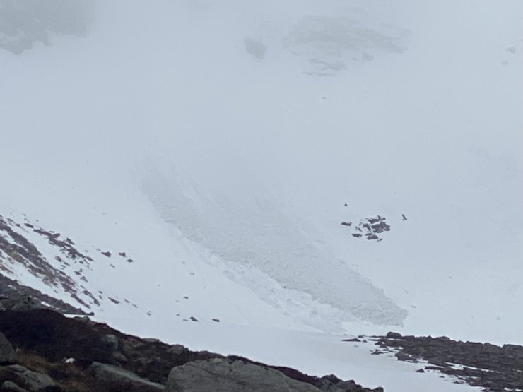
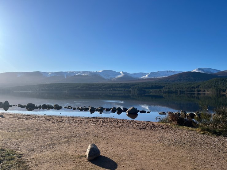
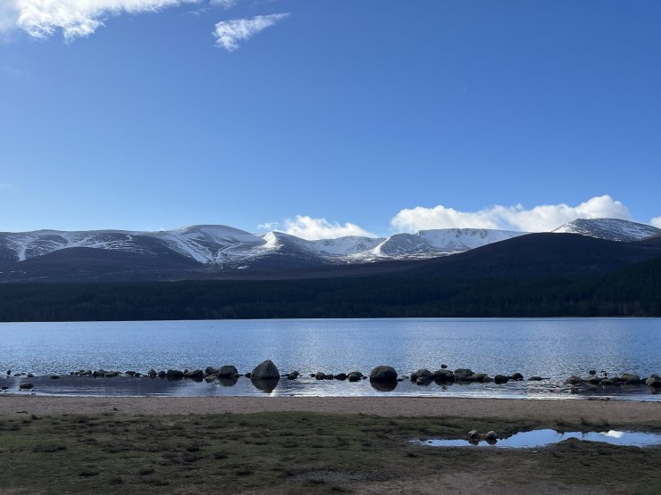
Keep up to date by subscribing to our RSS feed
This report is supported by